
Water Resources
Texas’ relationship with water can be summarized as a battle of growing demand against dwindling supplies. The state’s population is one of the fastest growing in the United States and is projected to increase more than 70% by 2070, with water demand going up 3.2 million acre-feet1,2. Historically, most of Texas’ water use has been for agriculture, but expanding populations are shifting focus to urban areas2,3. The previous geographic variability of water stress across the state—traditionally with east Texas being wetter than west Texas—is only becoming more uncertain in coming years and decades under climate change4,5,6.
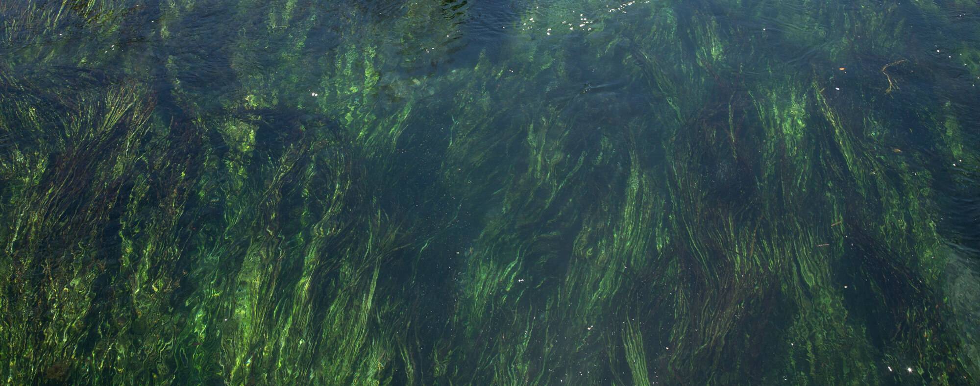
In Texas, surface water resources are divided among 15 primary river basins, with networks of dams and reservoirs to collect and distribute water2,3. Warmer and drier temperatures will increase evaporation from soils and open water bodies to reduce the total volume of lakes, rivers, streams, and reservoirs1,7. Surface water availability is projected to decline 10% by 2040 under more severe climate projection scenarios, combined with an estimated 5% decrease in soil moisture4,5. These percentages may seem small, but they translate to a loss of 1.6 million acre-feet2. While the number of extreme rainfall events will likely increase in the coming years, hotter temperatures negate any positive effect of excess precipitation on water availably; especially with the rise in megadrought frequency and severity1,3,6. The occurrence of consistent soaking rains is projected to decline, decreasing the number of light showers that consistently keep soils wet and plants happy, lengthening the average time between precipitation events8,9. A greater prevalence of drought exacerbates already water-intensive sectors such as agriculture and municipal use.
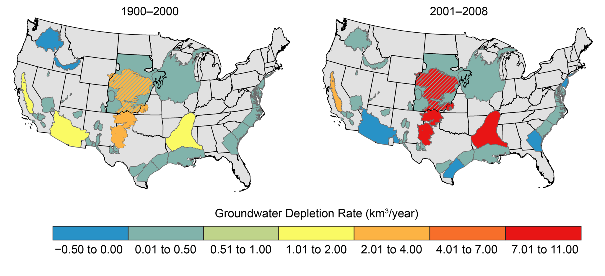
Texas primarily relies on groundwater, held under the surface in aquifers, to meet water demands5,9. There are nine major and 22 minor aquifers spread across the state, including the southern part of the Ogallala Aquifer, the largest in the country10. Many groundwater conservation districts presently plan to pump even more water over the long term, increasing the amount of unsustainable demand in the future11. Currently, groundwater is being pumped at a rate of 1.8 times over the maximum sustainable amount, increasing to 2.4 times the sustainable amount. The Ogallala is hit particularly hard, currently pumped at 6.5 times its sustainable capacity, and climbing11. This rise will probably happen in tandem with a decline in groundwater storage capacity due to slower recharge rates12,13,14. Agricultural irrigation demand will also probably increase while subsurface pumping infrastructure becomes more vulnerable from greater subsurface exposure to heating and freezing events3,15,16. Under current management practices, these circumstances paint a dire picture.
Water management in Texas is divided among different regions. A new local planning cycle is initiated every five years, which connects with regional and state-level action plans17. The state plan focuses on addressing demand 50-years into the future by using historical records to determine future supplies2. This “rear-view mirror approach” considers the worst drought events ever recorded and calculates the amount of available water at those times as the bottom-line minimum moving forwards2. Updating the plan every five years allows for recent changes in climate to be considered but does not address declines in water supply in the future due to climate change3.
Considering the short and long-term impacts of climate change is vital to sustainable water management in Texas1,3,11. A challenge to this is the spatial resolution of climate models, which require downscaling to be precise enough to accurately calculate future water availability for use in regional planning4,18. It is also important to consider surface and groundwater resources holistically while crafting water policies, as they interact in connected and complex ways with each other and water infrastructure3,19.
Failing to account for climate change puts Texas’ already stressed water resources, as well as its economy and people, at much greater risk20. Good climate change adaptation is good water management.
Learn more about water in Texas with the resources below.
Internet of Water: A new approach to improve access and storage of water data in the United States, making water data affordable and open source to increase water equity and resiliency for both developers and end-users.
OpenET: Aims to improve water management for the western US through satellite estimates of evapotranspiration.
Texas Shows Us Our Water Future with Climate Change: It Ain’t Pretty (Natural Resources Defense Council)
Texas Water Development Board: The goal of the Board since its founding in 1957 is to study, plan, and finance Texas’ water resources for current and future use. They provide many services and reports related to groundwater and surface-water planning, data collection and dissemination, conservation, flood planning and response, and financial and technical assistance services. The Board produces water reports for all state, private business, and local community stakeholders to read and incorporate into planning. The Board is the best source of water data and forecasts for the state, accessible through their Water Data for Texas page.
Texas Water Development Boards’ Drought Dashboard: Hosts resources for understanding drought in Texas with links to datasets and tools for drought status, impacts, outlook, and responses.
When It Rains, Texas Forgets Drought and Worsening Water Scarcity (Circle of Blue)
U.S. Drought Monitor: Tracks drought severity conditions for the entire United States to monitor trends and recognizing drought conditions to help reduce impacts while providing a historical record for research and planning.
References
- Kloesel, K., B. Bartush, J. Banner, D. Brown, J. Lemery, X. Lin, C. Loeffler, G. McManus, and others 2018. Chapter 23: Southern great plains. Impacts, risks, and adaptation in the United States: The fourth national climate assessment, volume II.S. Global Change Research Program.
- TWDB 2021. Texas Water Development Board: 2022 State Water Plan - Water for Texas. Retrieved from https://www.twdb.texas.gov/waterplanning/swp/2022/index.asp
- Nielsen-Gammon, J. W., J. L. Banner, B. I. Cook, D. M. Tremaine, C. I. Wong, R. E. Mace, H. Gao, Z.-L. Yang, and others 2020. Unprecedented drought challenges for Texas water resources in a changing climate: what do researchers and stakeholders need to know?Earth’s Future Wiley Online Library: e2020EF001552.
- Schewe, J., J. Heinke, D. Gerten, I. Haddeland, N. W. Arnell, D. B. Clark, R. Dankers, S. Eisner, and others 2014. Multimodel assessment of water scarcity under climate change.Proceedings of the National Academy of Sciences National Acad Sciences: 3245–3250.
- Seager, R., N. Lis, J. Feldman, M. Ting, A. P. Williams, J. Nakamura, H. Liu, and N. Henderson. 2018. Whither the 100th meridian? The once and future physical and human geography of America’s arid–humid divide. Part I: The story so far.Earth Interactions 22: 1–22.
- Nielsen-Gammon, J., S. Holman, A. Buley, S. Jorgensen, J. Escobedo, C. Ott, J. Dedrick, and A. Van Fleet. 2021. Assessment of Historic and Future Trends of Extreme Weather in Texas, 1900-2036. OSC-202101. Texas A&M University.
- Ehsani, N., C. J. Vörösmarty, B. M. Fekete, and E. Z. Stakhiv. 2017. Reservoir operations under climate change: Storage capacity options to mitigate risk.Journal of Hydrology Elsevier: 435–446.
- Seager, R., M. Ting, C. Li, N. Naik, B. Cook, J. Nakamura, and H. Liu. 2013. Projections of declining surface-water availability for the southwestern United States.Nature Climate Change Nature Publishing Group: 482–486.
- Wuebbles, D. J., D. W. Fahey, and K. A. Hibbard. 2017. Climate science special report: fourth national climate assessment, volume I.
- George, P. G., R. E. Mace, R. Petrossian, and others. 2011. Aquifers of Texas. 380. Texas Water Development Board Austin, TX.
- Mace, R. 2021. Five Gallons in a Ten Gallon Hat: Groundwater Sustainability in Texas. 2021–08. The Meadows Center for Water and the Environment - Texas State Univeristy.
- Mace, R. E., and S. C. Wade. 2008. In hot water? How climate change may (or may not) affect the groundwater resources of Texas. GCAGS Transactions.
- Taylor, R. G., B. Scanlon, P. Döll, M. Rodell, R. Van Beek, Y. Wada, L. Longuevergne, M. Leblanc, and others 2013. Ground water and climate change.Nature climate change Nature Publishing Group: 322–329.
- Yoon, J.-H., S. S. Wang, M.-H. Lo, and W.-Y. Wu. 2018. Concurrent increases in wet and dry extremes projected in Texas and combined effects on groundwater.Environmental Research Letters IOP Publishing: 054002.
- Busby, J. W., K. Baker, M. D. Bazilian, A. Q. Gilbert, E. Grubert, V. Rai, J. D. Rhodes, S. Shidore, and others 2021. Cascading risks: Understanding the 2021 winter blackout in Texas.Energy Research & Social Science Elsevier: 102106.
- Glazer, Y. R., D. M. Tremaine, J. L. Banner, M. Cook, R. E. Mace, J. Nielsen-Gammon, E. Grubert, K. Kramer, and others 2021. Winter Storm Uri: A Test of Texas’ Water Infrastructure and Water Resource Resilience to Extreme Winter Weather Events.Journal of Extreme Events. World Scientific: 2150022.
- Bruun, B. 2017. The regional water planning process: A Texas success story.Texas Water Journal 8: 1–12.
- Cartier, K. 2019. Bringing climate projections down to size for water managers.Eos
- Smith, B., B. Hunt, A. Andrews, J. Watson, M. Gary, D. Wierman, and A. Broun. 2015. Surface water–groundwater interactions along the Blanco River of central Texas, USA.Environmental Earth Sciences Springer: 7633–7642.
- Fan, Q., K. Fisher-Vanden, and H. A. Klaiber. 2018. Climate change, migration, and regional economic impacts in the United States.Journal of the Association of Environmental and Resource Economists University of Chicago Press Chicago, IL: 643–671.